Description
Bathymetry Survey
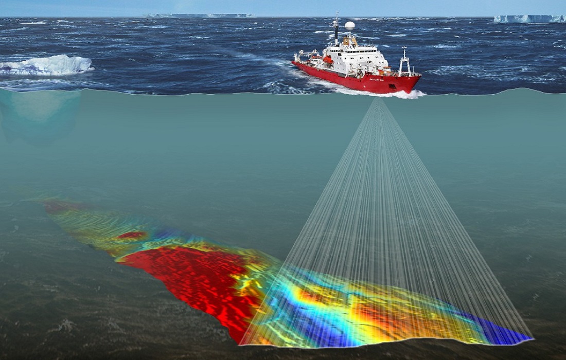
A bathymetry survey is the process of measuring the depth and topography of a water body, such as a river, lake, or ocean. It is the underwater equivalent of a topographic survey on land and provides detailed information about the submerged features of a water body, such as the shape of the seafloor, riverbed, or lakebed. These surveys are conducted using specialized equipment, such as echo sounders, multibeam sonar systems, or LiDAR, to map underwater terrain.
Importance of Bathymetry Survey
-
Water Resource Management
- Flood Prediction and Management: Bathymetry surveys provide detailed data on underwater features that affect the flow of water, such as submerged hills, channels, and valleys. This data is crucial for predicting flood risks, especially in rivers and reservoirs, and helps in designing flood control measures like dams, levees, and floodplain management strategies.
- Hydraulic Modeling: Bathymetric data is key in developing accurate hydraulic models, which simulate water flow and help in the design and management of water storage and distribution systems.
-
Navigation Safety
- Safe Passage for Vessels: Bathymetric surveys are essential for creating navigational charts and ensuring that ships, boats, and other watercraft can safely navigate through water bodies without running aground. Understanding the depth and underwater hazards like rocks, reefs, and sandbars is critical for marine safety.
- Port and Harbor Design: Bathymetric data is used to design and maintain ports, harbors, and shipping channels, ensuring they are deep enough to accommodate vessels of varying sizes and preventing blockages or accidents due to shallow areas.
-
Environmental Monitoring and Conservation
- Ecosystem Health: Bathymetric surveys help identify the underwater features that support aquatic ecosystems, such as coral reefs, submerged vegetation, and fish habitats. Monitoring changes in bathymetry over time can indicate shifts in ecosystems due to natural factors or human impacts, such as sedimentation, erosion, or pollution.
- Coastal Protection: In coastal areas, bathymetric data helps to assess the effects of tides, waves, and storm surges on the shoreline and underwater features. This is vital for coastal protection efforts, including the design of breakwaters and other shoreline stabilization structures.
-
Sediment Transport and Erosion Studies
- Sediment Movement: Bathymetric surveys provide insights into sediment transport dynamics by revealing areas of erosion and deposition on the riverbed or ocean floor. This information is critical for managing erosion, protecting infrastructure, and designing measures to mitigate sedimentation in reservoirs or coastal areas.
- Understanding River and Coastal Morphology: For rivers and coastal environments, bathymetric surveys help track the movement of sediment, which is crucial for managing sedimentation in reservoirs, river channels, and harbors.
-
Hydroelectric and Energy Projects
- Dam and Reservoir Design: Bathymetric data is essential for the design and maintenance of dams and reservoirs. By understanding the depth and shape of the reservoir bed, engineers can optimize storage capacity and improve flood control capabilities.
- Turbine Placement and Hydropower Planning: For hydroelectric projects, bathymetric surveys help in assessing the feasibility of dam sites and identifying optimal locations for turbine placement by providing a detailed understanding of the water flow and reservoir capacity.
-
Archaeological and Historical Research
- Underwater Exploration: Bathymetric surveys are used in underwater archaeology to locate and map submerged structures, shipwrecks, and other historical artifacts. Understanding the underwater topography helps researchers pinpoint potential sites for exploration and excavation.
- Preservation of Submerged Heritage: Bathymetry surveys also aid in monitoring the preservation of submerged cultural heritage, ensuring that historical sites and structures are protected from environmental damage or human activity.
-
Climate Change and Oceanography Studies
- Sea-Level Rise and Coastal Flooding: Bathymetric data plays an important role in studying the effects of sea-level rise due to climate change. It provides the baseline for monitoring changes in coastal areas, which is crucial for flood risk assessments and adaptation planning in vulnerable regions.
- Ocean Circulation and Climate Modeling: In oceanography, bathymetric data helps scientists understand ocean currents, wave dynamics, and other factors that influence climate patterns. Changes in the ocean floor can affect circulation patterns, which in turn impact weather systems.
Description for Website
A bathymetric survey is a critical process for mapping the underwater landscape of rivers, lakes, oceans, and other bodies of water. Using state-of-the-art technology such as sonar, LiDAR, or echo sounders, bathymetric surveys measure the depth, shape, and features of the submerged terrain. These surveys play a vital role in a wide range of industries, including navigation, environmental management, flood control, and hydroelectric projects.
The data collected through bathymetric surveys helps engineers, scientists, and conservationists understand water bodies’ morphology, sediment dynamics, and flow characteristics. It is essential for ensuring the safe navigation of vessels, designing effective flood protection systems, managing sedimentation, monitoring ecosystems, and supporting archaeological research.
Key Benefits:
- Accurate mapping of underwater features and topography.
- Enhanced safety for navigation and vessel traffic.
- Improved management of water resources, flood risks, and coastal areas.
- Support for environmental conservation and ecosystem monitoring.
- Essential for infrastructure design and maintenance (dams, ports, etc.).
Vital for climate change studies, including the impact of sea-level rise.


Reviews
There are no reviews yet.