Description
River Sediment Deposition Survey
A river sedimentation survey is a key process for understanding how sediments move and settle within rivers. It measures the type, amount, and distribution of sediments in the riverbed and water column. These surveys provide vital information for river management, infrastructure design, flood control, environmental protection, and ecosystem conservation. Using ADCP renting equipment makes these surveys faster, more accurate, and efficient for studying river sediment deposition.
Why River Sedimentation Surveys Matter
Flood Management and River Flow
Assessing Flood Risks: Sediment buildup can change a river’s depth, width, and slope, which may increase flood risks. Regular sediment deposition surveys help monitor these changes and guide effective flood control planning.
Maintaining River Capacity: Over time, sediment accumulation can reduce a river’s ability to carry water. With ADCP renting, surveys can track sediment levels, helping maintain proper water flow and avoid blockages.
Infrastructure Design and Maintenance
Dam and Reservoir Management: Sedimentation in dams can reduce reservoir capacity, impacting water supply and energy generation. Regular river sediment survey data ensures timely maintenance and removal.
River Channel Upkeep: Sediment accumulation can block channels and affect bridges, weirs, and culverts. Using ADCP renting, engineers can monitor and manage riverbed sedimentation efficiently.
Understanding Sediment Movement
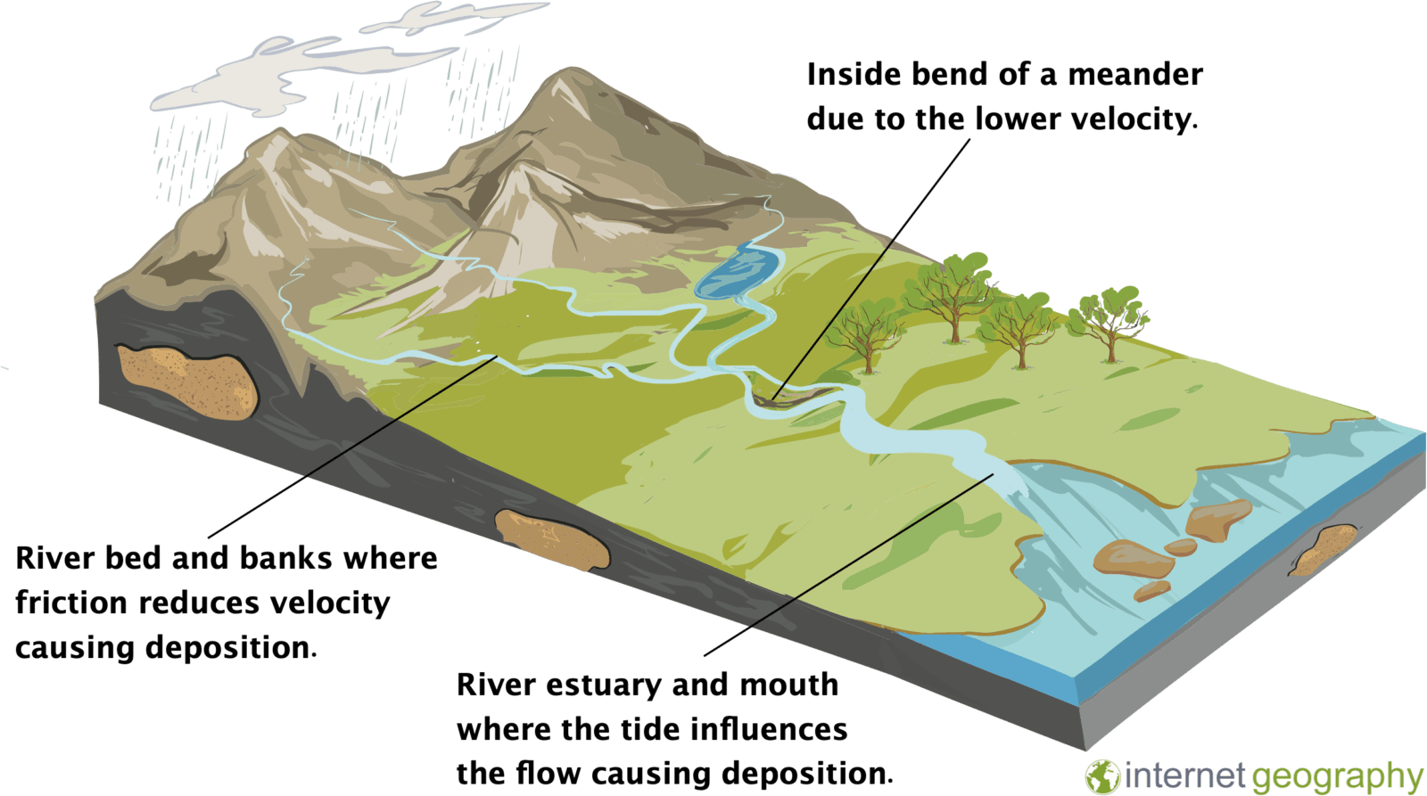
Tracking Sediment: Surveys measure how sand, silt, clay, and organic material move in a river. This helps understand sediment deposition in rivers and overall river morphology.
Erosion and Deposition: Monitoring sedimentation identifies areas of erosion or buildup, which is important for protecting riverbanks, infrastructure, and ecosystems.
Environmental and Water Quality Impact
Water Quality: Excess sediment can reduce water quality and affect aquatic life. Using ADCP renting helps detect problem areas and plan solutions.
Ecosystem Health: Sediment levels influence fish habitats and aquatic plants. Understanding river sediment deposition supports healthy ecosystems.
Hydropower and Energy Projects
Turbine Efficiency: Sediment can damage hydropower turbines. Surveys using ADCP renting help manage sediment loads and protect equipment.
Long-term Sustainability: Monitoring river sediment surveys ensures hydropower projects remain efficient and safe over time.
River Restoration and Conservation
Restoration Planning: Sedimentation surveys guide river restoration by identifying areas needing attention.
Sustainable Management: Understanding river sediment deposition helps balance human needs with natural ecosystems.
Adapting to Climate Change
Climate Impacts: Sedimentation surveys track changes caused by altered rainfall, storms, or rising sea levels.
Future Planning: Regular ADCP renting surveys help manage evolving sediment patterns effectively.
How Surveys Are Done
A river sedimentation survey collects and analyzes sediment data using tools like sediment samplers, corers, and sonar-based equipment. ADCP renting provides modern solutions for fast and accurate measurements.
Key Methods:
-
Sediment Sampling: Collecting samples at multiple points to study composition and concentration.
-
Hydraulic Profiling: Using acoustic devices to map riverbed topography and identify sediment buildup.
Applications:
-
Flood and erosion control
-
Environmental monitoring
-
Infrastructure planning and maintenance
-
Hydropower efficiency
Benefits:
-
Detailed understanding of sediment dynamics
-
Helps manage floods and maintain river flow
-
Supports infrastructure and ecosystem conservation
-
Optimizes hydropower operations
In short, a river sedimentation survey is essential for tracking river sediment deposition and ensuring sustainable river management. Using ADCP renting equipment makes this process accurate, efficient, and reliable for planning, conservation, and environmental protection.
Reviews
There are no reviews yet.